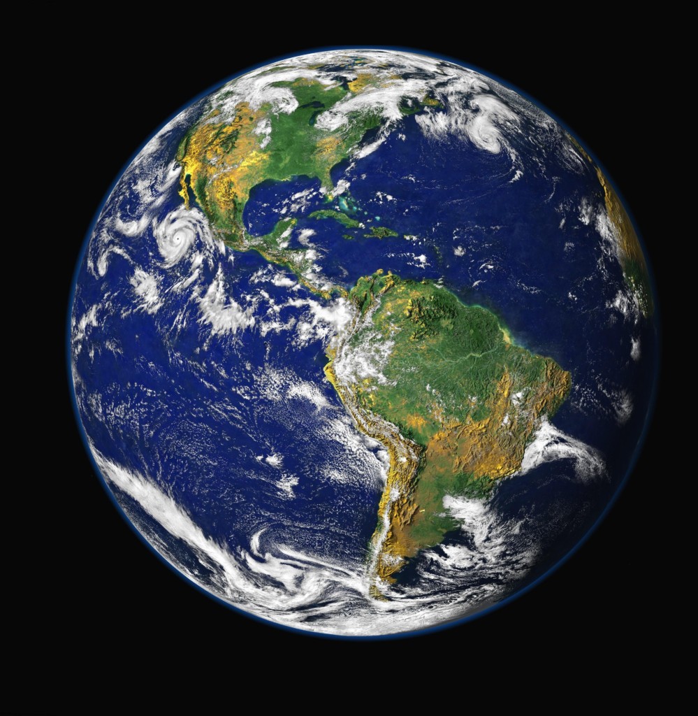
过去,地球多半被制成2D平面地图以利观赏,比例难免失衡,不过现在国外有个网站可以让你轻松比较各大洲和各国家的实际大小,一起来看看吧!
![earth](http://www.teepr.com/wp-content/uploads/2016/07/earth.jpg)
netimpact
其实很简单,土地离赤道越远,在地图上看起来就越大,而靠赤道越近就越小,所以离赤道近的国家,在地图上看起来都会比较小。
1. 首先因为地球是圆的,所以在视觉落差上,会发现美国的领土大小会随着你把它往北或往南移而有所改变。
![Firstly, you can see how the size of the US drastically changes as you move it north or south.](http://teepr.com/wp-content/uploads/2016/07/5791c65a0d2d0.jpg)
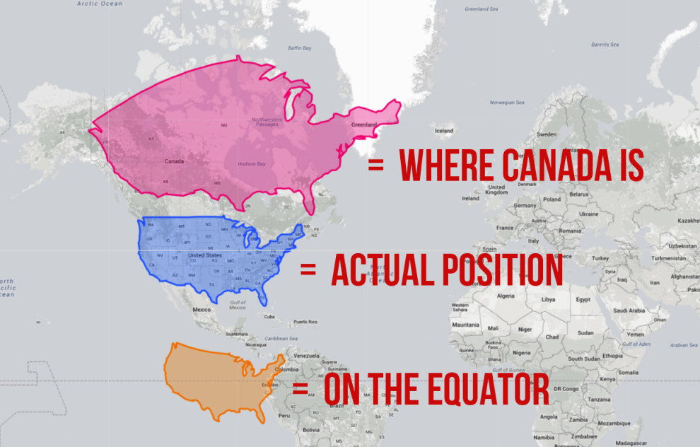
蓝色是美国现在的位置,如果今天把美国移到加拿大的位置,它的土地就会变大 (粉色),如果移到赤道上的话,国土就会缩水 (橘色)。
2. 如果今天换把加拿大移到美国的位置,它的领土就会变这样:
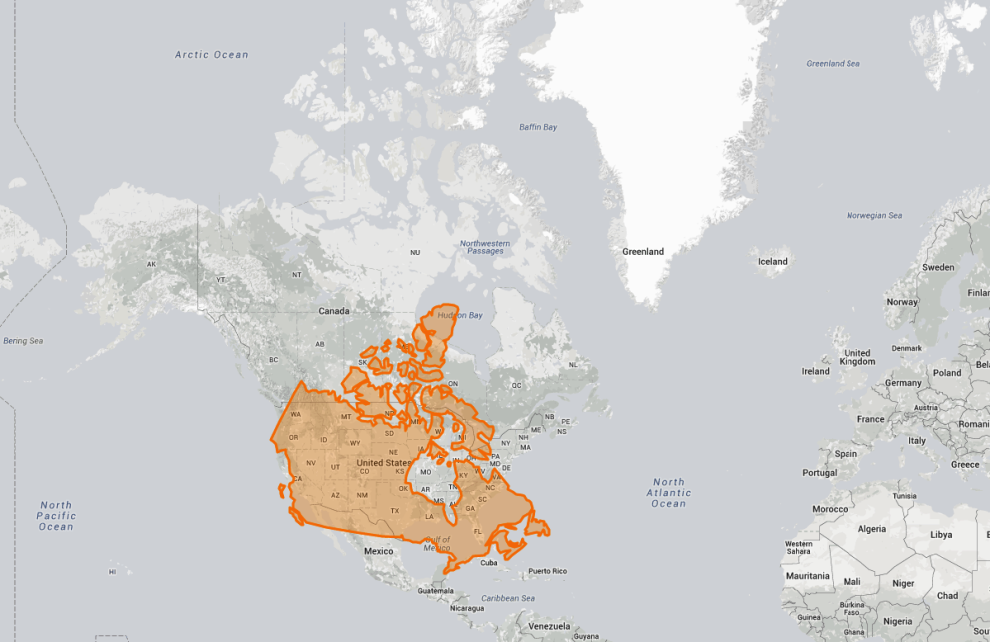
![And if Canada is moved down to where the US is, it's clear that they aren't as dissimilar in size as most people think.](http://teepr.com/wp-content/uploads/2016/07/5791c65ac6ec0.png)
不只缩小,形状也有些改变。
3. 如果把澳洲移到欧洲的位置,它的领土会变怎样呢?
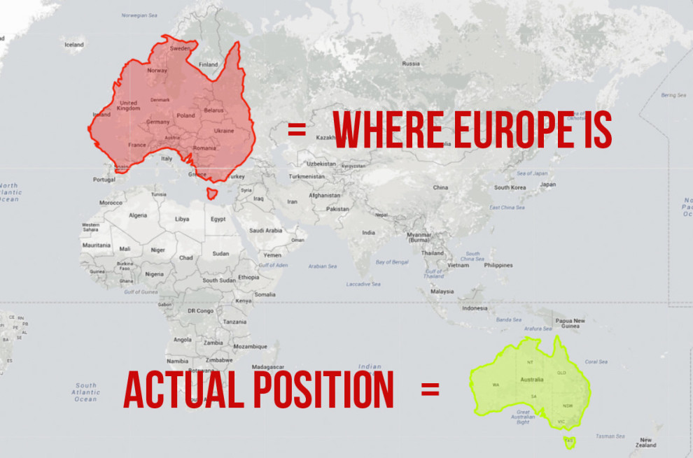
![People often forget how big Australia is because it's so far away from other land masses. Here's what happens when you move it over Europe.](http://teepr.com/wp-content/uploads/2016/07/5791c65b89afe.jpg)
不只变大也变长了!
4. 紧邻加拿大的阿拉斯加,如果把它往下拉的话…
![Back to Alaska – this map shows that, while it's still the biggest US state, it's nowhere near as big as most maps make it look.](http://teepr.com/wp-content/uploads/2016/07/5791c65c1ae4b.jpg)
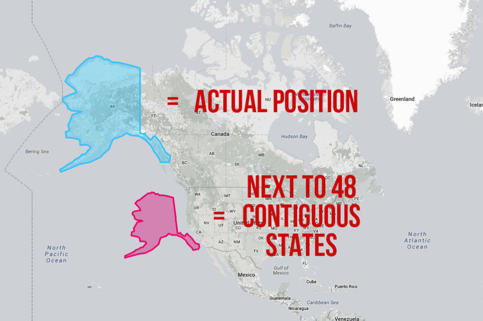
虽然土地变小了 (粉色),但还是美国面积最大的州!
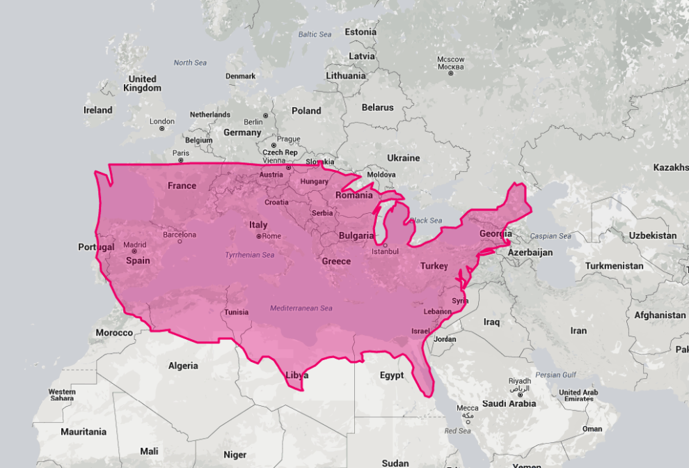
5. 如果把美国移到欧洲的话…
![This map shows how big the USA is compared with Europe, but it also does something else rather interesting...](http://teepr.com/wp-content/uploads/2016/07/5791c65ca4551.png)
6. 现在来看看台湾!
![撷取4](http://www.teepr.com/wp-content/uploads/2016/07/撷取4-13.jpg)
7. 如果把台湾移到北京旁边的话……
![撷取3](http://www.teepr.com/wp-content/uploads/2016/07/撷取3-17.jpg)
台湾和北京就快不相上下了!
8. 台湾移到美国旁边的话:
![撷取5](http://www.teepr.com/wp-content/uploads/2016/07/撷取5-16.jpg)
台湾面积小所以差异不大?
9. 如果台湾移到北极海:
![撷取0](http://www.teepr.com/wp-content/uploads/2016/07/撷取0-1.jpg)
就会变成头重脚轻的模样!
10. 那如果把中国移到赤道附近的话:
![撷取](http://www.teepr.com/wp-content/uploads/2016/07/撷取-7.jpg)
11. 如果中国湾跑去俄罗斯的位置:
![撷取7](http://www.teepr.com/wp-content/uploads/2016/07/撷取7-11.jpg)
有点像一只垂头丧气的公鸡?
12. 如果中国跑去南极的话:
![撷取6](http://www.teepr.com/wp-content/uploads/2016/07/撷取6-10.jpg)
变枫叶~
13. 把日本移到挪威旁边的话:
![撷取8](http://www.teepr.com/wp-content/uploads/2016/07/撷取8-8.jpg)
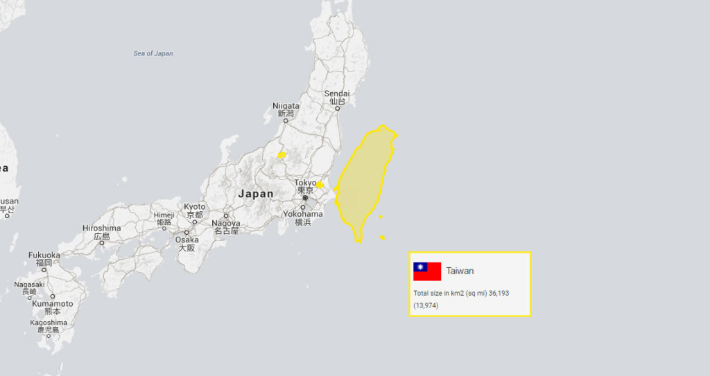
14. 又或者是把台湾移到日本旁边…其实还不小呢!
![taiwan](http://www.teepr.com/wp-content/uploads/2016/07/taiwan.jpg)
15. 最后,把世界上国土面积前10大的国家摆在赤道上,就会是这个模样:
![And finally, here's what happens when you place the 10 largest countries in the world next to each other on the equator.](http://teepr.com/wp-content/uploads/2016/07/5791c65d826f7.jpg)
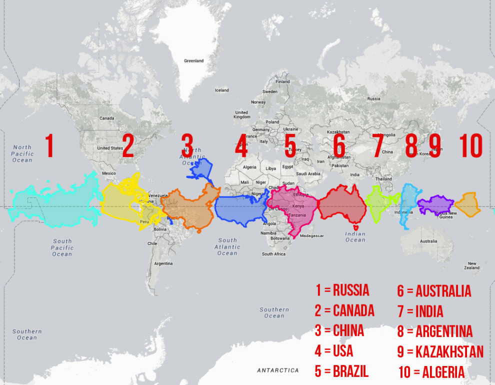
前10大的排名依序是俄罗斯、加拿大、中国、美国、巴西、澳洲、印度、阿根廷、哈萨克、阿尔及利亚。
(往下還有更多精彩文章!)